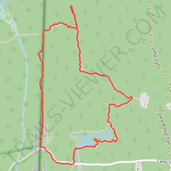
Yawgoog Pond Area Hiking Trails
- Distance: 2.4 mi
- Elevation gain: 27 m
- Maximum elevation: 129 m
- Elevation loss: 27 m
- Minimum elevation: 107 m
- Moving time: 1 h 4 m
- Moving speed: 2.2 mph
- Maximum speed: 5.8 mph
- Total time: 1 h 42 m
- Global speed: 1.4 mph
Interactive trail map
Trail profile
- Distance: 2.4 mi
- Elevation gain: 27 m
- Maximum elevation: 129 m
- Elevation loss: 27 m
- Minimum elevation: 107 m
- Moving time: 1 h 4 m
- Moving speed: 2.2 mph
- Maximum speed: 5.8 mph
- Total time: 1 h 42 m
- Global speed: 1.4 mph
About this trail
Name: Yawgoog Pond Area Hiking Trails trail, distance, elevation, map, profile, GPS track
End: Camp Yawgoog Road, Hopkinton, South County, Rhode Island, 02873, United States (41.52572 -71.78925)
Coordinates: 41.52572 -71.79236 41.53656 -71.78372