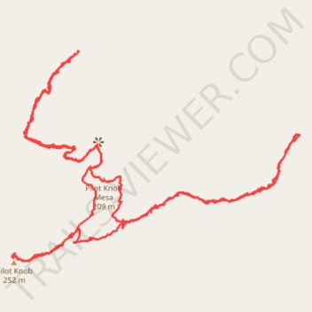
Pilot Knob
- Distance: 2.4 mi
- Elevation gain: 242 m
- Maximum elevation: 258 m
- Elevation loss: 243 m
- Minimum elevation: 104 m
- Moving time: 1 h 32 m
- Moving speed: 1.6 mph
- Maximum speed: 6.1 mph
- Total time: 2 h 5 m
- Global speed: 1.2 mph
Interactive trail map
Trail profile
- Distance: 2.4 mi
- Elevation gain: 242 m
- Maximum elevation: 258 m
- Elevation loss: 243 m
- Minimum elevation: 104 m
- Moving time: 1 h 32 m
- Moving speed: 1.6 mph
- Maximum speed: 6.1 mph
- Total time: 2 h 5 m
- Global speed: 1.2 mph
About this trail
Name: Pilot Knob trail, distance, elevation, map, profile, GPS track
Start: Sidewinder Road North, Imperial County, California, 93383, United States (32.73632 -114.74826)
End: Sidewinder Road North, Imperial County, California, 93383, United States (32.73642 -114.74816)
Coordinates: 32.73146 -114.75002 32.73642 -114.74197