Clear Creek and Azalea Trails Loop via Chestnut Mountain and Chilhowee Campground in Cherokee National Forest
- Distance: 15.0 mi
- Elevation gain: 612 m
- Maximum elevation: 602 m
- Elevation loss: 612 m
- Minimum elevation: 264 m
- Moving time: 4 h 37 m
- Moving speed: 3.2 mph
- Maximum speed: 4.5 mph
- Total time: 4 h 39 m
- Global speed: 3.2 mph
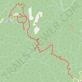
Interactive trail map
Trail profile
- Distance: 15.0 mi
- Elevation gain: 612 m
- Maximum elevation: 602 m
- Elevation loss: 612 m
- Minimum elevation: 264 m
- Moving time: 4 h 37 m
- Moving speed: 3.2 mph
- Maximum speed: 4.5 mph
- Total time: 4 h 39 m
- Global speed: 3.2 mph
About this trail
Name: Clear Creek and Azalea Trails Loop via Chestnut Mountain and Chilhowee Campground in Cherokee National Forest trail, distance, elevation, map, profile, GPS track
Start: 476, SR 30, Polk County, East Tennessee, Tennessee, 37369, United States (35.12023 -84.56854)
End: 476, SR 30, Polk County, East Tennessee, Tennessee, 37369, United States (35.12023 -84.56852)
Coordinates: 35.12020 -84.60810 35.15843 -84.56852
Other hiking, mountain biking, running and outdoor activity trails
Click on a trail to view its statistics, map and profile.
Slick Rock Loop Trail, Dana FS Road, Scenic Overlook and Naked Widow Loop Trail
United States > Tennessee > Polk County
Chilhowee Mountain
Distance: 9.8 mi • Elevation gain: 462 m • Maximum elevation: 702 m
Loop hike from Ocoee Lake via Clemmer Spur, Clear Creek, Benton Falls and Clemmer
United States > Tennessee > Polk County
Distance: 9.9 mi • Elevation gain: 513 m • Maximum elevation: 570 m
Clear Creek Trail and Mulepen Branch Trail
United States > Tennessee > Polk County
Distance: 13.0 mi • Elevation gain: 509 m • Maximum elevation: 603 m