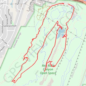
Red Rock Canyon Loop
Loop hike through Red Rock Canyon Open Space via Contemplative Trail, Roundup Trail, Mesa Trail, Greenlee Trail, Quarry Pass Trail, Lyons Sandstone Quarry and Red Rock Canyon Trail. #Hiking #Loop #Rock #Nature #Canyon #Forest
- Distance: 4.5 mi
- Elevation gain: 203 m
- Maximum elevation: 2,009 m
- Elevation loss: 205 m
- Minimum elevation: 1,883 m
- Moving time: 2 h 1 m
- Moving speed: 2.2 mph
- Maximum speed: 3.6 mph
- Total time: 2 h 26 m
- Global speed: 1.8 mph
Interactive trail map
Trail profile
- Distance: 4.5 mi
- Elevation gain: 203 m
- Maximum elevation: 2,009 m
- Elevation loss: 205 m
- Minimum elevation: 1,883 m
- Moving time: 2 h 1 m
- Moving speed: 2.2 mph
- Maximum speed: 3.6 mph
- Total time: 2 h 26 m
- Global speed: 1.8 mph
About this trail
Name: Red Rock Canyon Loop trail, distance, elevation, map, profile, GPS track
Coordinates: 38.84065 -104.89146 38.85364 -104.87842
Other hiking, mountain biking, running and outdoor activity trails
Click on a trail to view its statistics, map and profile.
Mesa Trail, Greenlee Trail, and Red Rock Canyon Trail Loop in Red Rock Canyon Open Space
United States > Colorado > El Paso County > Colorado Springs
The Mesa, Greenlee, and Red Rock Canyon Trails Loop in Colorado Springs offers a pleasant hike through Red Rock Canyon Open Space, combining gentle inclines and peaceful scenery. The trail features expansive views of Garden of the Gods, a tranquil pond, and unique sandstone formations shaped by historic…
Distance: 1.8 mi • Elevation gain: 69 m • Maximum elevation: 1,941 m
Red Rock Canyon
United States > Colorado > El Paso County > Colorado Springs
Chamberlain Trail
Distance: 1.1 mi • Elevation gain: 82 m • Maximum elevation: 1,967 m