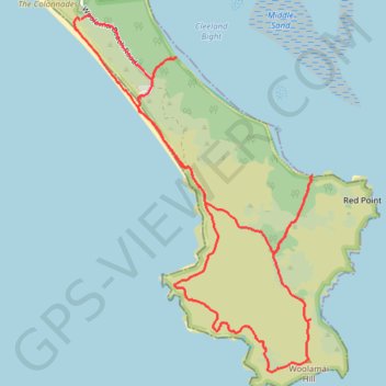
Cape Woolamai - Phillip Island
- Distance: 7.3 mi
- Elevation gain: 323 m
- Maximum elevation: 104 m
- Elevation loss: 324 m
- Minimum elevation: 0 m
- Moving time: 1 h 28 m
- Moving speed: 5.0 mph
- Maximum speed: 14.7 mph
- Total time: 1 h 45 m
- Global speed: 4.2 mph
Interactive trail map
Trail profile
- Distance: 7.3 mi
- Elevation gain: 323 m
- Maximum elevation: 104 m
- Elevation loss: 324 m
- Minimum elevation: 0 m
- Moving time: 1 h 28 m
- Moving speed: 5.0 mph
- Maximum speed: 14.7 mph
- Total time: 1 h 45 m
- Global speed: 4.2 mph
About this trail
Name: Cape Woolamai - Phillip Island trail, distance, elevation, map, profile, GPS track
Coordinates: -38.56583 145.33341 -38.53762 145.35752
Other hiking, mountain biking, running and outdoor activity trails
Click on a trail to view its statistics, map and profile.