Import a GPX file

Arboretum has a new connector path

First light after main shingles sizzles ♨️. Super day!

  • Distance: 4.1 mi
  • Elevation gain: 49 m
  • Maximum elevation: 232 m
  • Elevation loss: 53 m
  • Minimum elevation: 208 m
  • Moving time: 1 h 24 m
  • Moving speed: 2.9 mph
  • Maximum speed: 7.7 mph
  • Total time: 1 h 27 m
  • Global speed: 2.8 mph

Interactive trail map

Trail profile

  • Distance: 4.1 mi
  • Elevation gain: 49 m
  • Maximum elevation: 232 m
  • Elevation loss: 53 m
  • Minimum elevation: 208 m
  • Moving time: 1 h 24 m
  • Moving speed: 2.9 mph
  • Maximum speed: 7.7 mph
  • Total time: 1 h 27 m
  • Global speed: 2.8 mph

About this trail
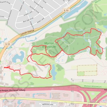
Name: Arboretum has a new connector path trail, distance, elevation, map, profile, GPS track

Start: Morton Arboretum, 4100, Westminster Street, Lisle, DuPage County, Illinois, 60532, United States (41.81457 -88.06671)

End: Visitor Center, Meadow Lake Trail, DuPage County, Illinois, 60532, United States (41.81395 -88.07109)

Coordinates: 41.81187 -88.07228 41.82000 -88.05065

Gear up for your next adventure:

🖼️Topographic Map Art - Decorative 3D-effect posters of famous UK peaks and regions
🧢Thermal Beanie Hats - Prevent heat loss from the head in windy summit conditions
❄️Walking Crampons - Added traction for icy slopes and winter peak bagging
🔋Solar Power Banks - Keep your GPS and phone charged during multi-day expeditions
🌦️Portable Weather Meters - Handheld tools for monitoring weather conditions

As an Amazon Associate, this site earns from qualifying purchases at no extra cost to you.