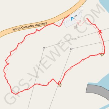
Gorge Dam - Gorge Lake
- Distance: 0.5 mi
- Elevation gain: 55 m
- Maximum elevation: 349 m
- Elevation loss: 46 m
- Minimum elevation: 314 m
- Moving time: 12 m 2 s
- Moving speed: 2.7 mph
- Maximum speed: 4.4 mph
- Total time: 14 m 30 s
- Global speed: 2.3 mph
Interactive trail map
Trail profile
- Distance: 0.5 mi
- Elevation gain: 55 m
- Maximum elevation: 349 m
- Elevation loss: 46 m
- Minimum elevation: 314 m
- Moving time: 12 m 2 s
- Moving speed: 2.7 mph
- Maximum speed: 4.4 mph
- Total time: 14 m 30 s
- Global speed: 2.3 mph
About this trail
Name: Gorge Dam - Gorge Lake trail, distance, elevation, map, profile, GPS track
Start: North Cascades Highway, Whatcom County, Washington, United States (48.70014 -121.20968)
End: North Cascades Highway, Whatcom County, Washington, United States (48.70024 -121.21036)
Coordinates: 48.69815 -121.21297 48.70024 -121.20897
Other hiking, mountain biking, running and outdoor activity trails
Click on a trail to view its statistics, map and profile.
Northern part of the Pacific Crest Trail (PCT)
United States > Oregon > Klamath County
Hike on the Pacific Crest National Scenic Trail from Crater Lake to Canada Border through Oregon and Washington along the Sierra Nevada and Cascade mountain ranges. #Hiking #Mountain #SierraNevada #Cascade #Nature #Forest #Park #PCT
Distance: 744.6 mi • Elevation gain: 44,308 m • Maximum elevation: 2,307 m