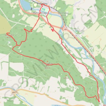
Dunfallandy Hill Loop via An Suidhe
eMTB Gravel - Pitlochry ‘Escape Route’ Cafe -> Dunfallandy Stone - Loop
- Distance: 12.7 mi
- Elevation gain: 529 m
- Maximum elevation: 404 m
- Elevation loss: 529 m
- Minimum elevation: 78 m
- Moving time: 1 h 32 m
- Moving speed: 8.2 mph
- Maximum speed: 22.7 mph
- Total time: 1 h 37 m
- Global speed: 7.8 mph
Interactive trail map
Trail profile
- Distance: 12.7 mi
- Elevation gain: 529 m
- Maximum elevation: 404 m
- Elevation loss: 529 m
- Minimum elevation: 78 m
- Moving time: 1 h 32 m
- Moving speed: 8.2 mph
- Maximum speed: 22.7 mph
- Total time: 1 h 37 m
- Global speed: 7.8 mph
About this trail
Name: Dunfallandy Hill Loop via An Suidhe trail, distance, elevation, map, profile, GPS track
Coordinates: 56.65386 -3.76225 56.70168 -3.67982
Topography: Perth and Kinross topographic map, elevation, terrain
Other hiking, mountain biking, running and outdoor activity trails
Click on a trail to view its statistics, map and profile.
EMTB Gravel: Pitlochry Highlights - Loop
United Kingdom > Scotland > Perth and Kinross > Pitlochry
Distance: 10.1 mi • Elevation gain: 559 m • Maximum elevation: 449 m
Loch Tummel Loop
United Kingdom > Scotland > Perth and Kinross > Pitlochry
To Escape Route Cafe UK, Perthshire, Loch Tummel
Distance: 28.7 mi • Elevation gain: 819 m • Maximum elevation: 289 m