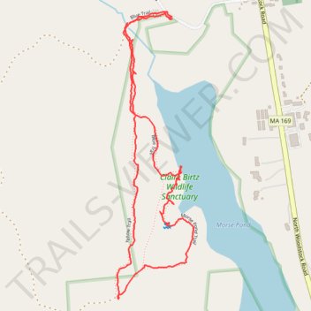
Loop walk at Claire Birtz Wildlife Sanctuary
- Distance: 1.8 mi
- Elevation gain: 65 m
- Maximum elevation: 192 m
- Elevation loss: 66 m
- Minimum elevation: 158 m
- Moving time: 56 m 15 s
- Moving speed: 2.0 mph
- Maximum speed: 4.7 mph
- Total time: 1 h 7 m
- Global speed: 1.6 mph
Interactive trail map
Trail profile
- Distance: 1.8 mi
- Elevation gain: 65 m
- Maximum elevation: 192 m
- Elevation loss: 66 m
- Minimum elevation: 158 m
- Moving time: 56 m 15 s
- Moving speed: 2.0 mph
- Maximum speed: 4.7 mph
- Total time: 1 h 7 m
- Global speed: 1.6 mph
About this trail
Name: Loop walk at Claire Birtz Wildlife Sanctuary trail, distance, elevation, map, profile, GPS track
Coordinates: 42.02920 -72.01818 42.03763 -72.01516
Other hiking, mountain biking, running and outdoor activity trails
Click on a trail to view its statistics, map and profile.
Walking the Blue and Red trails at Claire Birtz Wildlife Sanctuary
United States > Massachusetts > Worcester County > Southbridge
Distance: 1.9 mi • Elevation gain: 74 m • Maximum elevation: 208 m