Thank you for supporting this site ❤️
Make a donation
Make a donation
Gear up for your next adventure:
As an Amazon Associate, this site earns from qualifying purchases at no extra cost to you.
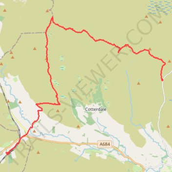
Hike from Buttertubs Pass to Garsdale via Great Shunner Fell and Lunds Fell
- Distance: 12.3 mi
- Elevation gain: 394 m
- Maximum elevation: 716 m
- Elevation loss: 572 m
- Minimum elevation: 307 m
- Moving time: 5 h 19 m
- Moving speed: 2.3 mph
- Maximum speed: 23.1 mph
- Total time: 6 h 49 m
- Global speed: 1.8 mph
Interactive trail map
Thank you for supporting this site ❤️
Make a donation
Make a donation
Gear up for your next adventure:
As an Amazon Associate, this site earns from qualifying purchases at no extra cost to you.
Trail profile
- Distance: 12.3 mi
- Elevation gain: 394 m
- Maximum elevation: 716 m
- Elevation loss: 572 m
- Minimum elevation: 307 m
- Moving time: 5 h 19 m
- Moving speed: 2.3 mph
- Maximum speed: 23.1 mph
- Total time: 6 h 49 m
- Global speed: 1.8 mph
Thank you for supporting this site ❤️
Make a donation
Make a donation
Gear up for your next adventure:
As an Amazon Associate, this site earns from qualifying purchases at no extra cost to you.
About this trail
Name: Hike from Buttertubs Pass to Garsdale via Great Shunner Fell and Lunds Fell trail, distance, elevation, map, profile, GPS track
Coordinates: 54.32052 -2.32855 54.38389 -2.20290
Topography: North Yorkshire topographic map, elevation, terrain
Thank you for supporting this site ❤️
Make a donation
Make a donation
Gear up for your next adventure:
As an Amazon Associate, this site earns from qualifying purchases at no extra cost to you.