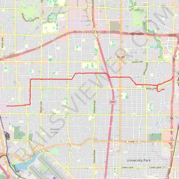
Biking the Northaven Trail
- Distance: 16.8 mi
- Elevation gain: 138 m
- Maximum elevation: 192 m
- Elevation loss: 137 m
- Minimum elevation: 142 m
- Moving time: 1 h 22 m
- Moving speed: 12.3 mph
- Maximum speed: 25.7 mph
- Total time: 1 h 22 m
- Global speed: 12.3 mph
Interactive trail map
Trail profile
- Distance: 16.8 mi
- Elevation gain: 138 m
- Maximum elevation: 192 m
- Elevation loss: 137 m
- Minimum elevation: 142 m
- Moving time: 1 h 22 m
- Moving speed: 12.3 mph
- Maximum speed: 25.7 mph
- Total time: 1 h 22 m
- Global speed: 12.3 mph
About this trail
Name: Biking the Northaven Trail trail, distance, elevation, map, profile, GPS track
End: 10716, Pagewood Drive, Dallas, Dallas County, Texas, 75230, United States (32.89310 -96.77803)
Coordinates: 32.88486 -96.87860 32.90326 -96.76962
Other hiking, mountain biking, running and outdoor activity trails
Click on a trail to view its statistics, map and profile.
White Rock Creek Trail up to Northaven Trail
United States > Texas > Dallas County > Dallas
Distance: 6.7 mi • Elevation gain: 75 m • Maximum elevation: 176 m
Cycling in Dallas and Park Cities
United States > Texas > Dallas County > Dallas > Gifford
Distance: 26.8 mi • Elevation gain: 281 m • Maximum elevation: 195 m
Cycling in Dallas, TX
United States > Texas > Dallas County > Dallas
Distance: 6.1 mi • Elevation gain: 60 m • Maximum elevation: 192 m