Hurricane Hill (Olympic National Park)
Hike to Hurricane Hill via Big Meadow Nature Trail, Cirque Rim Nature Trail, Little River Viewpoint Nature Trail, Hurricane Ridge Road and Hurricane Hill Nature Trail in the Daniel J. Evans Wilderness and the Olympic National Park. #Hile #Mountain #Nature #Forest #Park #Olympic #Wilderness
- Distance: 6.5 mi
- Elevation gain: 449 m
- Maximum elevation: 1,741 m
- Elevation loss: 449 m
- Minimum elevation: 1,495 m
- Moving time: 2 h 24 m
- Moving speed: 2.7 mph
- Maximum speed: 5.2 mph
- Total time: 2 h 47 m
- Global speed: 2.3 mph
Interactive trail map
Trail profile
- Distance: 6.5 mi
- Elevation gain: 449 m
- Maximum elevation: 1,741 m
- Elevation loss: 449 m
- Minimum elevation: 1,495 m
- Moving time: 2 h 24 m
- Moving speed: 2.7 mph
- Maximum speed: 5.2 mph
- Total time: 2 h 47 m
- Global speed: 2.3 mph
About this trail
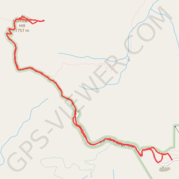
Name: Hurricane Hill (Olympic National Park) trail, distance, elevation, map, profile, GPS track
Start: Cirque Rim Nature Trail, Clallam County, Washington, United States (47.96992 -123.49730)
End: Big Meadow Nature Trail, Clallam County, Washington, United States (47.96990 -123.49729)
Coordinates: 47.96958 -123.53238 47.99032 -123.49729
Other hiking, mountain biking, running and outdoor activity trails
Click on a trail to view its statistics, map and profile.
Klahhane Ridge
United States > Washington > Clallam County
Hike from Hurricane Ridge to Klahhane Ridge via Big Meadow Natural Trail, Cirque Rim Nature Trail, High Ridge Nature Trail, Sunrise Viewpoint, Hurricane Ridge to Switchback Trail, Switchback Trail and Klahhane Ridge Trail in the Olympic National Park and the Daniel J. Evans Wilderness. #Hiking #Mountain…
Distance: 8.2 mi • Elevation gain: 796 m • Maximum elevation: 1,836 m
Hurricane Hill Nature Trail in Olympic National Park
United States > Washington > Clallam County
The Hurricane Hill Nature Trail offers a relatively easy, yet rewarding hike within Olympic National Park, providing stunning panoramic views from Hurricane Ridge. As you ascend, you'll be treated to sweeping vistas of snow-capped peaks, including Mount Olympus, while also spotting vibrant wildflower meadows…
Distance: 1.6 mi • Elevation gain: 243 m • Maximum elevation: 1,743 m