Suffolk Coastal Trail Running
Woodbridge
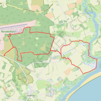
- Distance: 13.7 mi
- Elevation gain: 118 m
- Maximum elevation: 28 m
- Elevation loss: 118 m
- Minimum elevation: -3 m
- Moving time: 2 h 28 m
- Moving speed: 5.5 mph
- Maximum speed: 9.8 mph
- Total time: 2 h 33 m
- Global speed: 5.4 mph
Interactive trail map
Trail profile
- Distance: 13.7 mi
- Elevation gain: 118 m
- Maximum elevation: 28 m
- Elevation loss: 118 m
- Minimum elevation: -3 m
- Moving time: 2 h 28 m
- Moving speed: 5.5 mph
- Maximum speed: 9.8 mph
- Total time: 2 h 33 m
- Global speed: 5.4 mph
About this trail
Name: Suffolk Coastal Trail Running trail, distance, elevation, map, profile, GPS track
Coordinates: 52.06175 1.40505 52.09016 1.49715
Topography: East Suffolk topographic map, elevation, terrain
Other hiking, mountain biking, running and outdoor activity trails
Click on a trail to view its statistics, map and profile.
Tunstall Forest and Rendlesham Forest Loop from Bawdsey Manor
United Kingdom > England > Suffolk > East Suffolk > Bawdsey
Distance: 40.5 mi • Elevation gain: 403 m • Maximum elevation: 34 m