Import a GPX file

Hiking trails in the Zoar Valley Unique Area

  • Distance: 2.3 mi
  • Elevation gain: 103 m
  • Maximum elevation: 431 m
  • Elevation loss: 67 m
  • Minimum elevation: 385 m
  • Moving time: 1 h 5 m
  • Moving speed: 2.1 mph
  • Maximum speed: 9.5 mph
  • Total time: 1 h 19 m
  • Global speed: 1.7 mph

Interactive trail map

Trail profile

  • Distance: 2.3 mi
  • Elevation gain: 103 m
  • Maximum elevation: 431 m
  • Elevation loss: 67 m
  • Minimum elevation: 385 m
  • Moving time: 1 h 5 m
  • Moving speed: 2.1 mph
  • Maximum speed: 9.5 mph
  • Total time: 1 h 19 m
  • Global speed: 1.7 mph

About this trail
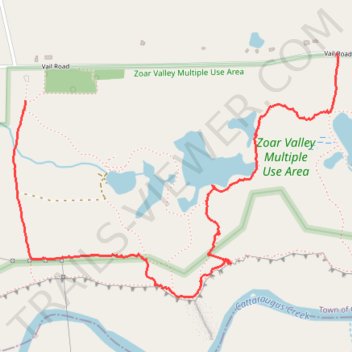
Name: Hiking trails in the Zoar Valley Unique Area trail, distance, elevation, map, profile, GPS track

Start: Holcomb Pond Trail, Town of Collins, Erie County, New York, 14035, United States (42.45010 -78.87937)

End: Zoar Holcomb Pond parking lot, Vail Road, Town of Collins, Erie County, New York, 14070, United States (42.45190 -78.86281)

Coordinates: 42.44241 -78.87997 42.45193 -78.86264

Gear up for your next adventure:

🛑Emergency Bivvy Bags - Heat-reflective survival bags for unexpected nights out
🚲Cycling GPS Computers - Track elevation and topographic routes on two wheels
📷Camera Straps - Secure straps for carrying cameras while walking
🗺️Topographic Maps - Detailed maps showing elevation and terrain features
🧴Sport Sunscreen Sticks - High-protection sunblock that won't run into your eyes on the trail

As an Amazon Associate, this site earns from qualifying purchases at no extra cost to you.