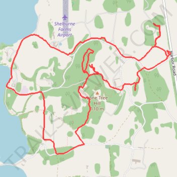
Shelburne Farms Loop
- Distance: 7.1 mi
- Elevation gain: 171 m
- Maximum elevation: 94 m
- Elevation loss: 170 m
- Minimum elevation: 25 m
- Moving time: 1 h 8 m
- Moving speed: 6.2 mph
- Maximum speed: 11.0 mph
- Total time: 1 h 9 m
- Global speed: 6.1 mph
Interactive trail map
Trail profile
- Distance: 7.1 mi
- Elevation gain: 171 m
- Maximum elevation: 94 m
- Elevation loss: 170 m
- Minimum elevation: 25 m
- Moving time: 1 h 8 m
- Moving speed: 6.2 mph
- Maximum speed: 11.0 mph
- Total time: 1 h 9 m
- Global speed: 6.1 mph
About this trail
Name: Shelburne Farms Loop trail, distance, elevation, map, profile, GPS track
End: Harbor Road, Shelburne, Chittenden County, Vermont, 05482, United States (44.39602 -73.24742)
Coordinates: 44.38279 -73.27741 44.40014 -73.24711
Other hiking, mountain biking, running and outdoor activity trails
Click on a trail to view its statistics, map and profile.
Around lake Champlain with ferry between Essex NY/Charlotte VT
United States > Vermont > Chittenden County > South Burlington
Distance: 138.4 mi • Elevation gain: 1,742 m • Maximum elevation: 198 m