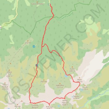
Carnic - Lacul Pietrele - vf. Peleaga - vf.Papusa - Portile ...
- Distance: 16.2 mi
- Elevation gain: 1,955 m
- Maximum elevation: 2,490 m
- Elevation loss: 1,949 m
- Minimum elevation: 992 m
- Moving time: 8 h 39 m
- Moving speed: 1.9 mph
- Maximum speed: 5.5 mph
- Total time: 13 h 56 m
- Global speed: 1.2 mph
Interactive trail map
Trail profile
- Distance: 16.2 mi
- Elevation gain: 1,955 m
- Maximum elevation: 2,490 m
- Elevation loss: 1,949 m
- Minimum elevation: 992 m
- Moving time: 8 h 39 m
- Moving speed: 1.9 mph
- Maximum speed: 5.5 mph
- Total time: 13 h 56 m
- Global speed: 1.2 mph
About this trail
Name: Carnic - Lacul Pietrele - vf. Peleaga - vf.Papusa - Portile ... trail, distance, elevation, map, profile, GPS track
Start: Popasul Cârnic, DJ667A, Sălașu de Sus, Hunedoara, 337423, Romania (45.43481 22.89392)
End: Popasul Cârnic, DJ667A, Sălașu de Sus, Hunedoara, 337423, Romania (45.43464 22.89377)
Coordinates: 45.36557 22.87278 45.43481 22.92277
Other hiking, mountain biking, running and outdoor activity trails
Click on a trail to view its statistics, map and profile.
Carnic - Peleaga - Bucura1 - Retezat - Muntii Retezat
Romania > Hunedoara > Sălașu de Sus
Distance: 16.2 mi • Elevation gain: 2,027 m • Maximum elevation: 2,490 m
Carnic - vârful Retezat
Romania > Hunedoara > Sălașu de Sus
Distance: 13.2 mi • Elevation gain: 1,603 m • Maximum elevation: 2,475 m