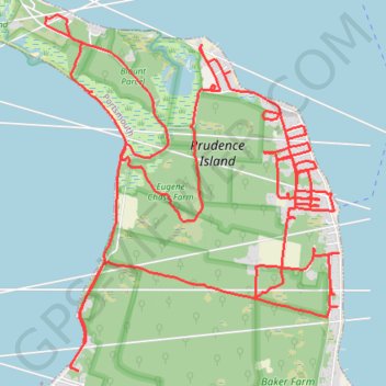
Prudence Island
Portsmouth Running
- Distance: 13.7 mi
- Elevation gain: 267 m
- Maximum elevation: 48 m
- Elevation loss: 268 m
- Minimum elevation: -3 m
- Moving time: 2 h 6 m
- Moving speed: 6.5 mph
- Maximum speed: 13.6 mph
- Total time: 2 h 13 m
- Global speed: 6.1 mph
Interactive trail map
Trail profile
- Distance: 13.7 mi
- Elevation gain: 267 m
- Maximum elevation: 48 m
- Elevation loss: 268 m
- Minimum elevation: -3 m
- Moving time: 2 h 6 m
- Moving speed: 6.5 mph
- Maximum speed: 13.6 mph
- Total time: 2 h 13 m
- Global speed: 6.1 mph
About this trail
Name: Prudence Island trail, distance, elevation, map, profile, GPS track
Coordinates: 41.60683 -71.33300 41.63295 -71.30415
Other hiking, mountain biking, running and outdoor activity trails
Click on a trail to view its statistics, map and profile.
Prudence Island
United States > Rhode Island > Newport County > Portsmouth
Portsmouth Running
Distance: 9.7 mi • Elevation gain: 97 m • Maximum elevation: 18 m