Import a GPX file

Perimeter Trail at Southeast Park

  • Distance: 1.8 mi
  • Elevation gain: 28 m
  • Maximum elevation: 80 m
  • Elevation loss: 28 m
  • Minimum elevation: 65 m
  • Moving time: 52 m 6 s
  • Moving speed: 2.0 mph
  • Maximum speed: 2.4 mph
  • Total time: 52 m 6 s
  • Global speed: 2.0 mph

Interactive trail map

Trail profile

  • Distance: 1.8 mi
  • Elevation gain: 28 m
  • Maximum elevation: 80 m
  • Elevation loss: 28 m
  • Minimum elevation: 65 m
  • Moving time: 52 m 6 s
  • Moving speed: 2.0 mph
  • Maximum speed: 2.4 mph
  • Total time: 52 m 6 s
  • Global speed: 2.0 mph

About this trail
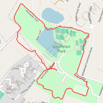
Name: Perimeter Trail at Southeast Park trail, distance, elevation, map, profile, GPS track

Start: Main Trail, Hazelwood Acres, Richland County, South Carolina, 29209, United States (33.96107 -80.93260)

End: Main Trail, Hazelwood Acres, Richland County, South Carolina, 29209, United States (33.96107 -80.93260)

Coordinates: 33.95913 -80.93607 33.96555 -80.93001

Gear up for your next adventure:

🦯Walking Poles - Supportive poles for long-distance walking
🧥Breathable Waterproof Jackets - Essential rain protection for the unpredictable British climate
🧼Technical Clothing Wash - Special soap to clean and restore waterproof membranes
🌄Outdoor Binoculars - Compact binoculars for landscape observation
🧣Fleece Neck Warmers - Extra insulation for winter topographic surveys

As an Amazon Associate, this site earns from qualifying purchases at no extra cost to you.