Thank you for supporting this site ❤️
Make a donation
Make a donation
Gear up for your next adventure:
As an Amazon Associate, this site earns from qualifying purchases at no extra cost to you.
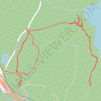
Newark Watershed 5a
- Distance: 4.0 mi
- Elevation gain: 168 m
- Maximum elevation: 365 m
- Elevation loss: 217 m
- Minimum elevation: 283 m
- Moving time: 2 h 18 m
- Moving speed: 1.7 mph
- Maximum speed: 2.7 mph
- Total time: 4 h 20 m
- Global speed: 0.9 mph
Interactive trail map
Thank you for supporting this site ❤️
Make a donation
Make a donation
Gear up for your next adventure:
As an Amazon Associate, this site earns from qualifying purchases at no extra cost to you.
Trail profile
- Distance: 4.0 mi
- Elevation gain: 168 m
- Maximum elevation: 365 m
- Elevation loss: 217 m
- Minimum elevation: 283 m
- Moving time: 2 h 18 m
- Moving speed: 1.7 mph
- Maximum speed: 2.7 mph
- Total time: 4 h 20 m
- Global speed: 0.9 mph
Thank you for supporting this site ❤️
Make a donation
Make a donation
Gear up for your next adventure:
As an Amazon Associate, this site earns from qualifying purchases at no extra cost to you.
About this trail
Name: Newark Watershed 5a trail, distance, elevation, map, profile, GPS track
Start: Highlands Trail, West Milford, Passaic County, New Jersey, United States (41.08487 -74.47960)
End: Canistear Road, West Milford, Passaic County, New Jersey, United States (41.08162 -74.49185)
Coordinates: 41.07958 -74.49211 41.08742 -74.47847
Thank you for supporting this site ❤️
Make a donation
Make a donation
Gear up for your next adventure:
As an Amazon Associate, this site earns from qualifying purchases at no extra cost to you.