Thank you for supporting this site ❤️
Make a donation
Make a donation
Gear up for your next adventure:
As an Amazon Associate, this site earns from qualifying purchases at no extra cost to you.
Blue Mountain Peak (Jamaica's highest summit)
Interactive trail map
Thank you for supporting this site ❤️
Make a donation
Make a donation
Gear up for your next adventure:
As an Amazon Associate, this site earns from qualifying purchases at no extra cost to you.
Trail profile
- Distance: 10.6 mi
- Elevation gain: 1,342 m
- Maximum elevation: 2,233 m
- Elevation loss: 1,342 m
- Minimum elevation: 1,224 m
Thank you for supporting this site ❤️
Make a donation
Make a donation
Gear up for your next adventure:
As an Amazon Associate, this site earns from qualifying purchases at no extra cost to you.
About this trail
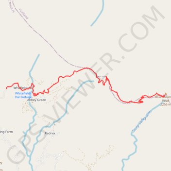
Name: Blue Mountain Peak (Jamaica's highest summit) trail, distance, elevation, map, profile, GPS track
Start: Whitfield Hall Road, Whitfield Hall, Saint Thomas, Surrey County, Jamaica (18.04827 -76.62270)
End: Whitfield Hall Road, Whitfield Hall, Saint Thomas, Surrey County, Jamaica (18.04827 -76.62270)
Coordinates: 18.04459 -76.62270 18.05371 -76.57922
Thank you for supporting this site ❤️
Make a donation
Make a donation
Gear up for your next adventure:
As an Amazon Associate, this site earns from qualifying purchases at no extra cost to you.