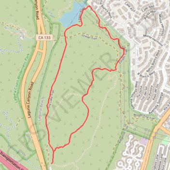
Make a donation
Gear up for your next adventure:
As an Amazon Associate, this site earns from qualifying purchases at no extra cost to you.
Barbara's Lake Loop
Interactive trail map
Make a donation
Gear up for your next adventure:
As an Amazon Associate, this site earns from qualifying purchases at no extra cost to you.
Trail profile
- Distance: 2.8 mi
- Elevation gain: 105 m
- Maximum elevation: 182 m
- Elevation loss: 105 m
- Minimum elevation: 94 m
Make a donation
Gear up for your next adventure:
As an Amazon Associate, this site earns from qualifying purchases at no extra cost to you.
About this trail
Name: Barbara's Lake Loop trail, distance, elevation, map, profile, GPS track
Start: Canyon Trail, Laguna Beach, Orange County, California, 92637, United States (33.59547 -117.75969)
End: The Lake Trail, Laguna Beach, Orange County, California, 92637, United States (33.59556 -117.75954)
Coordinates: 33.59547 -117.76030 33.61064 -117.75126
Make a donation
Gear up for your next adventure:
As an Amazon Associate, this site earns from qualifying purchases at no extra cost to you.