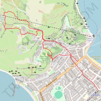
Great Orme
- Distance: 3.4 mi
- Elevation gain: 233 m
- Maximum elevation: 204 m
- Elevation loss: 230 m
- Minimum elevation: 7 m
- Moving time: 1 h 29 m
- Moving speed: 2.3 mph
- Maximum speed: 4.5 mph
- Total time: 2 h 6 m
- Global speed: 1.6 mph
Interactive trail map
Trail profile
- Distance: 3.4 mi
- Elevation gain: 233 m
- Maximum elevation: 204 m
- Elevation loss: 230 m
- Minimum elevation: 7 m
- Moving time: 1 h 29 m
- Moving speed: 2.3 mph
- Maximum speed: 4.5 mph
- Total time: 2 h 6 m
- Global speed: 1.6 mph
About this trail
Name: Great Orme trail, distance, elevation, map, profile, GPS track
Coordinates: 53.32074 -3.85272 53.33348 -3.82735
Topography: Conwy topographic map, elevation, terrain
Other hiking, mountain biking, running and outdoor activity trails
Click on a trail to view its statistics, map and profile.
Great Orme Summit and Loop
United Kingdom > Wales > Conwy > Llandudno
Distance: 5.9 mi • Elevation gain: 357 m • Maximum elevation: 204 m