Make a donation
Gear up for your next adventure:
As an Amazon Associate, this site earns from qualifying purchases at no extra cost to you.
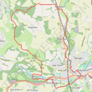
Circuit from Stapleford
- Distance: 13.0 mi
- Elevation gain: 181 m
- Maximum elevation: 125 m
- Elevation loss: 180 m
- Minimum elevation: 37 m
- Moving time: 4 h 58 m
- Moving speed: 2.6 mph
- Maximum speed: 3.7 mph
- Total time: 6 h 4 m
- Global speed: 2.1 mph
Interactive trail map
Make a donation
Gear up for your next adventure:
As an Amazon Associate, this site earns from qualifying purchases at no extra cost to you.
Trail profile
- Distance: 13.0 mi
- Elevation gain: 181 m
- Maximum elevation: 125 m
- Elevation loss: 180 m
- Minimum elevation: 37 m
- Moving time: 4 h 58 m
- Moving speed: 2.6 mph
- Maximum speed: 3.7 mph
- Total time: 6 h 4 m
- Global speed: 2.1 mph
Make a donation
Gear up for your next adventure:
As an Amazon Associate, this site earns from qualifying purchases at no extra cost to you.
About this trail
Name: Circuit from Stapleford trail, distance, elevation, map, profile, GPS track
Coordinates: 51.78807 -0.14706 51.83901 -0.07928
Topography: East Hertfordshire topographic map, elevation, terrain
Make a donation
Gear up for your next adventure:
As an Amazon Associate, this site earns from qualifying purchases at no extra cost to you.
Other hiking, mountain biking, running and outdoor activity trails
Click on a trail to view its statistics, map and profile.
Hertfordshire Chain Walk 5&6
United Kingdom > England > Hertfordshire > East Hertfordshire > Hertford > Hertingfordbury
Distance: 12.3 mi • Elevation gain: 188 m • Maximum elevation: 126 m