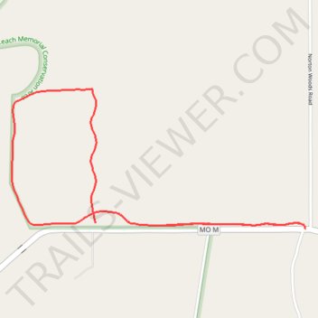
BK Leach Memorial Conservation Area
- Distance: 2.7 mi
- Elevation gain: 10 m
- Maximum elevation: 136 m
- Elevation loss: 9 m
- Minimum elevation: 132 m
- Moving time: 59 m 56 s
- Moving speed: 2.7 mph
- Maximum speed: 4.0 mph
- Total time: 59 m 56 s
- Global speed: 2.7 mph
Interactive trail map
Trail profile
- Distance: 2.7 mi
- Elevation gain: 10 m
- Maximum elevation: 136 m
- Elevation loss: 9 m
- Minimum elevation: 132 m
- Moving time: 59 m 56 s
- Moving speed: 2.7 mph
- Maximum speed: 4.0 mph
- Total time: 59 m 56 s
- Global speed: 2.7 mph
About this trail
Name: BK Leach Memorial Conservation Area trail, distance, elevation, map, profile, GPS track
Start: MO M, Lincoln County, Missouri, United States (39.12260 -90.73668)
End: MO M, Lincoln County, Missouri, United States (39.12247 -90.73330)
Coordinates: 39.12231 -90.74197 39.12917 -90.72336