Mouse's Tank
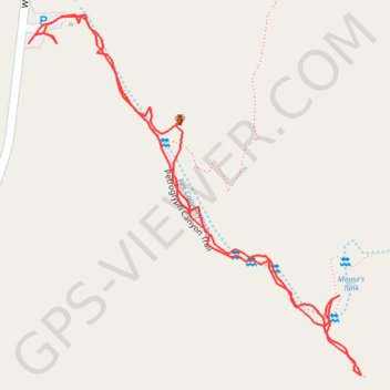
Hike along Fire Canyon Wash to Mouse's Tank via Petroglyph Canyon Trail in the Valley of Fire State Park. #Hiking #Nature #Desert #Rock #Park
- Distance: 1.1 mi
- Elevation gain: 40 m
- Maximum elevation: 643 m
- Elevation loss: 40 m
- Minimum elevation: 624 m
- Moving time: 37 m 12 s
- Moving speed: 1.7 mph
- Maximum speed: 4.0 mph
- Total time: 1 h 5 m
- Global speed: 1.0 mph
Interactive trail map
Trail profile
- Distance: 1.1 mi
- Elevation gain: 40 m
- Maximum elevation: 643 m
- Elevation loss: 40 m
- Minimum elevation: 624 m
- Moving time: 37 m 12 s
- Moving speed: 1.7 mph
- Maximum speed: 4.0 mph
- Total time: 1 h 5 m
- Global speed: 1.0 mph
About this trail
Name: Mouse's Tank trail, distance, elevation, map, profile, GPS track
Start: Petroglyph Canyon Trail, Clark County, Nevada, United States (36.44076 -114.51666)
End: White Domes Road, Clark County, Nevada, United States (36.44079 -114.51664)
Coordinates: 36.43699 -114.51666 36.44109 -114.51196