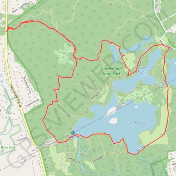
Borderland Park Loop
Loop hike in the Borderland State Park via Northwest Trail, Split Rock Trail, Granite Hills Trail, Granite Hills Lower Loop, Tisdale Road, Upper Leach Pond, Puds Pond, Pond Walk, Leach Pond, Pond Edge Trail, West Side Trail and The French Trail. #Hiking #Loop #Park #Nature #Lake #Forest
- Distance: 5.9 mi
- Elevation gain: 81 m
- Maximum elevation: 97 m
- Elevation loss: 82 m
- Minimum elevation: 63 m
- Moving time: 3 h 9 m
- Moving speed: 1.9 mph
- Maximum speed: 3.7 mph
- Total time: 3 h 30 m
- Global speed: 1.7 mph
Interactive trail map
Trail profile
- Distance: 5.9 mi
- Elevation gain: 81 m
- Maximum elevation: 97 m
- Elevation loss: 82 m
- Minimum elevation: 63 m
- Moving time: 3 h 9 m
- Moving speed: 1.9 mph
- Maximum speed: 3.7 mph
- Total time: 3 h 30 m
- Global speed: 1.7 mph
About this trail
Name: Borderland Park Loop trail, distance, elevation, map, profile, GPS track
Start: Northwest Trail, Sharon, Norfolk County, Massachusetts, 02067, United States (42.07560 -71.17240)
Coordinates: 42.06109 -71.17257 42.07668 -71.14706
Other hiking, mountain biking, running and outdoor activity trails
Click on a trail to view its statistics, map and profile.
Cambridge - Providence Express
United States > Massachusetts > Middlesex County > Cambridge
Alewife -> Providence
Distance: 63.2 mi • Elevation gain: 961 m • Maximum elevation: 107 m
Dedham-Providence-Dedham
United States > Massachusetts > Norfolk County > Dedham
Distance: 126.0 mi • Elevation gain: 1,811 m • Maximum elevation: 167 m