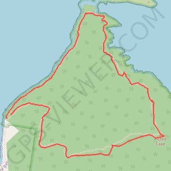
Import a GPX file

Fluted Cape

Bruny Island. Bruny National Park. #Hiking #Loop #Bruny #Tasmania

  • Distance: 3.1 mi
  • Elevation gain: 342 m
  • Maximum elevation: 265 m
  • Elevation loss: 348 m
  • Minimum elevation: 3 m

Interactive trail map

Trail profile

  • Distance: 3.1 mi
  • Elevation gain: 342 m
  • Maximum elevation: 265 m
  • Elevation loss: 348 m
  • Minimum elevation: 3 m

About this trail

Name: Fluted Cape trail, distance, elevation, map, profile, GPS track

Start: Fluted Cape Track, South Bruny, Kingborough, Tasmania, 7150, Australia (-43.35883 147.35893)

End: Fluted Cape Track, South Bruny, Kingborough, Tasmania, 7150, Australia (-43.35911 147.35850)

Coordinates: -43.36211 147.35846 -43.35098 147.37520

Gear up for your next adventure:

🧷Tenacious Repair Tape - Instant fix for torn tents, jackets, or dry bags
👟Waterproof Leg Gaiters - Keep mud and water out of your boots in boggy terrain
📍Handheld GPS Navigators - Reliable satellite navigation for hiking and off-road exploration
🔦LED Camping Lanterns - Illumination for reading maps inside your tent at night
🧭Emergency Beacons - Safety beacons for remote outdoor locations

As an Amazon Associate, this site earns from qualifying purchases at no extra cost to you.