Girraween Creek and Peak Tracks
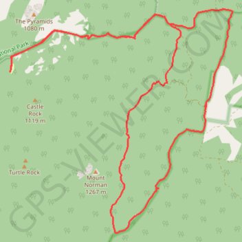
Interactive trail map
Trail profile
- Distance: 18.3 mi
- Elevation gain: 510 m
- Maximum elevation: 1,108 m
- Elevation loss: 510 m
- Minimum elevation: 873 m
About this trail
Name: Girraween Creek and Peak Tracks trail, distance, elevation, map, profile, GPS track
Coordinates: -28.87751 151.93778 -28.82071 152.00216
Other hiking, mountain biking, running and outdoor activity trails
Click on a trail to view its statistics, map and profile.
Wallangara - Stanthorpe
Australia > New South Wales > Jennings
#MTB
Distance: 44.0 mi • Elevation gain: 798 m • Maximum elevation: 880 m
Wallangara - Stanthorpe
Australia > Queensland > Wallangarra
#Bike
Distance: 34.6 mi • Elevation gain: 635 m • Maximum elevation: 880 m
Stanthorpe - Wallangara
Australia > Queensland > Stanthorpe
#Bike
Distance: 30.2 mi • Elevation gain: 676 m • Maximum elevation: 1,096 m