Cottonwood Trail
- Distance: 7.7 mi
- Elevation gain: 150 m
- Maximum elevation: 246 m
- Elevation loss: 146 m
- Minimum elevation: 192 m
- Moving time: 2 h 30 m
- Moving speed: 3.0 mph
- Maximum speed: 13.7 mph
- Total time: 2 h 31 m
- Global speed: 3.0 mph
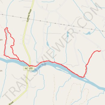
Interactive trail map
Trail profile
- Distance: 7.7 mi
- Elevation gain: 150 m
- Maximum elevation: 246 m
- Elevation loss: 146 m
- Minimum elevation: 192 m
- Moving time: 2 h 30 m
- Moving speed: 3.0 mph
- Maximum speed: 13.7 mph
- Total time: 2 h 31 m
- Global speed: 3.0 mph
About this trail
Name: Cottonwood Trail trail, distance, elevation, map, profile, GPS track
Start: Cottonwood Trail, Cleveland County, North Carolina, United States (35.20163 -81.66304)
End: River Trail, Cleveland County, North Carolina, 28017, United States (35.20198 -81.66477)
Coordinates: 35.19839 -81.67478 35.21338 -81.63888
Other hiking, mountain biking, running and outdoor activity trails
Click on a trail to view its statistics, map and profile.
Broad River Greenway Trails
United States > North Carolina > Cleveland County > Boiling Springs
Distance: 6.3 mi • Elevation gain: 191 m • Maximum elevation: 253 m
Broad River Southside trail
United States > North Carolina > Cleveland County
Distance: 2.4 mi • Elevation gain: 47 m • Maximum elevation: 209 m