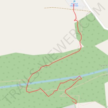
Waterfall walk
- Distance: 0.3 mi
- Elevation gain: 26 m
- Maximum elevation: 260 m
- Elevation loss: 8 m
- Minimum elevation: 234 m
- Moving time: 14 m 9 s
- Moving speed: 1.4 mph
- Maximum speed: 4.5 mph
- Total time: 19 m 13 s
- Global speed: 1.1 mph
Interactive trail map
Trail profile
- Distance: 0.3 mi
- Elevation gain: 26 m
- Maximum elevation: 260 m
- Elevation loss: 8 m
- Minimum elevation: 234 m
- Moving time: 14 m 9 s
- Moving speed: 1.4 mph
- Maximum speed: 4.5 mph
- Total time: 19 m 13 s
- Global speed: 1.1 mph
About this trail
Name: Waterfall walk trail, distance, elevation, map, profile, GPS track
Start: Dol Henrhyd, Coelbren, Powys, Wales, SA10 9PG, United Kingdom (51.79365 -3.66451)
End: Dol Henrhyd, Coelbren, Powys, Wales, SA10 9PG, United Kingdom (51.79558 -3.66446)
Coordinates: 51.79359 -3.66598 51.79558 -3.66420
Topography: Powys topographic map, elevation, terrain
Other hiking, mountain biking, running and outdoor activity trails
Click on a trail to view its statistics, map and profile.
The Headstock 500
United Kingdom > Wales > Newport > Newport
Distance: 300.4 mi • Elevation gain: 9,616 m • Maximum elevation: 691 m