Canyon Creek Hike
- Distance: 4.5 mi
- Elevation gain: 324 m
- Maximum elevation: 1,988 m
- Elevation loss: 323 m
- Minimum elevation: 1,710 m
- Moving time: 1 h 54 m
- Moving speed: 2.4 mph
- Maximum speed: 6.1 mph
- Total time: 2 h 9 m
- Global speed: 2.1 mph
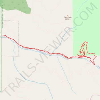
Interactive trail map
Trail profile
- Distance: 4.5 mi
- Elevation gain: 324 m
- Maximum elevation: 1,988 m
- Elevation loss: 323 m
- Minimum elevation: 1,710 m
- Moving time: 1 h 54 m
- Moving speed: 2.4 mph
- Maximum speed: 6.1 mph
- Total time: 2 h 9 m
- Global speed: 2.1 mph
About this trail
Name: Canyon Creek Hike trail, distance, elevation, map, profile, GPS track
Start: Canyon Creek Drive, Bountiful, Davis County, Utah, 84010, United States (40.84598 -111.85251)
End: Canyon Creek Drive, Bountiful, Davis County, Utah, 84010, United States (40.84612 -111.85249)
Coordinates: 40.84003 -111.85260 40.84621 -111.82725
Other hiking, mountain biking, running and outdoor activity trails
Click on a trail to view its statistics, map and profile.