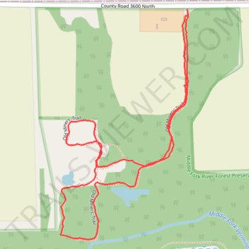
Old Miner's Loop Trail
- Distance: 1.8 mi
- Elevation gain: 11 m
- Maximum elevation: 223 m
- Elevation loss: 11 m
- Minimum elevation: 217 m
- Moving time: 46 m 36 s
- Moving speed: 2.3 mph
- Maximum speed: 3.5 mph
- Total time: 52 m
- Global speed: 2.1 mph
Interactive trail map
Trail profile
- Distance: 1.8 mi
- Elevation gain: 11 m
- Maximum elevation: 223 m
- Elevation loss: 11 m
- Minimum elevation: 217 m
- Moving time: 46 m 36 s
- Moving speed: 2.3 mph
- Maximum speed: 3.5 mph
- Total time: 52 m
- Global speed: 2.1 mph
About this trail
Name: Old Miner's Loop Trail trail, distance, elevation, map, profile, GPS track
Start: Old Miners' Trail, Champaign County, Illinois, United States (40.39880 -87.97568)
End: Old Miners' Trail, Champaign County, Illinois, United States (40.39895 -87.97570)
Coordinates: 40.39170 -87.98093 40.39895 -87.97566