Thank you for supporting this site ❤️
Make a donation
Make a donation
Gear up for your next adventure:
As an Amazon Associate, this site earns from qualifying purchases at no extra cost to you.
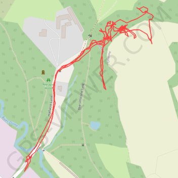
RE SK370780 2
- Distance: 1.6 mi
- Elevation gain: 40 m
- Maximum elevation: 132 m
- Elevation loss: 40 m
- Minimum elevation: 102 m
- Moving time: 1 h 3 m
- Moving speed: 1.5 mph
- Maximum speed: 3.8 mph
- Total time: 23 h 9 m
- Global speed: 0.1 mph
Interactive trail map
Thank you for supporting this site ❤️
Make a donation
Make a donation
Gear up for your next adventure:
As an Amazon Associate, this site earns from qualifying purchases at no extra cost to you.
Trail profile
- Distance: 1.6 mi
- Elevation gain: 40 m
- Maximum elevation: 132 m
- Elevation loss: 40 m
- Minimum elevation: 102 m
- Moving time: 1 h 3 m
- Moving speed: 1.5 mph
- Maximum speed: 3.8 mph
- Total time: 23 h 9 m
- Global speed: 0.1 mph
Thank you for supporting this site ❤️
Make a donation
Make a donation
Gear up for your next adventure:
As an Amazon Associate, this site earns from qualifying purchases at no extra cost to you.
About this trail
Name: RE SK370780 2 trail, distance, elevation, map, profile, GPS track
Coordinates: 53.29496 -1.44929 53.29849 -1.44467
Topography: North East Derbyshire topographic map, elevation, terrain
Thank you for supporting this site ❤️
Make a donation
Make a donation
Gear up for your next adventure:
As an Amazon Associate, this site earns from qualifying purchases at no extra cost to you.