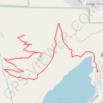
Rattlesnake Ledge
Interactive trail map
Trail profile
- Distance: 5.4 mi
- Elevation gain: 648 m
- Maximum elevation: 705 m
- Elevation loss: 648 m
- Minimum elevation: 277 m
About this trail
Name: Rattlesnake Ledge trail, distance, elevation, map, profile, GPS track
Coordinates: 47.43299 -121.78504 47.43965 -121.76837
Other hiking, mountain biking, running and outdoor activity trails
Click on a trail to view its statistics, map and profile.
Rattlesnake Mountain and Windy Landing from Rattlesnake Lake via Rattlesnake Ledge Trail and Rattlesnake Mountain Trail
United States > Washington > King County
The hike to Rattlesnake Mountain offers a captivating journey through both dense forests and exposed ridges. The first stretch to the ledge provides stunning views of the Rattlesnake Lake and surrounding peaks like Mount Si and Mailbox Peak, while ascending further on the mountain trail leads to quieter spots…
Distance: 9.9 mi • Elevation gain: 976 m • Maximum elevation: 1,051 m
Rattlesnake Ledge Trail from Rattlesnake Lake in Rattlesnake Mountain Scenic Area
United States > Washington > King County
The Rattlesnake Ledge Trail offers a scenic and invigorating hike that begins at Rattlesnake Lake and ascends through lush forested areas. As you gain elevation, you'll be treated to expansive views of Rattlesnake Lake, the surrounding Cascade foothills, and, from the summit, panoramic vistas of the Southern…
Distance: 4.4 mi • Elevation gain: 451 m • Maximum elevation: 608 m
Rattlesnake Ledge Trail in Cedar River Municipal Watershed
United States > Washington > King County
The Rattlesnake Ledge Trail offers a rewarding hiking experience with well-maintained paths that wind through lush forests, leading to stunning viewpoints over Rattlesnake Lake and the surrounding Cascade Mountains. The moderate incline is manageable for most hikers, providing ample opportunities to admire…
Distance: 5.5 mi • Elevation gain: 607 m • Maximum elevation: 705 m
Northern part of the Pacific Crest Trail (PCT)
United States > Oregon > Klamath County
Hike on the Pacific Crest National Scenic Trail from Crater Lake to Canada Border through Oregon and Washington along the Sierra Nevada and Cascade mountain ranges. #Hiking #Mountain #SierraNevada #Cascade #Nature #Forest #Park #PCT
Distance: 744.6 mi • Elevation gain: 44,308 m • Maximum elevation: 2,307 m