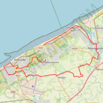
1 - 32 km (32 km) - 08 Jun 21
- Distance: 19.9 mi
- Elevation gain: 117 m
- Maximum elevation: 25 m
- Elevation loss: 113 m
- Minimum elevation: -2 m
Interactive trail map
Trail profile
- Distance: 19.9 mi
- Elevation gain: 117 m
- Maximum elevation: 25 m
- Elevation loss: 113 m
- Minimum elevation: -2 m
About this trail
Name: 1 - 32 km (32 km) - 08 Jun 21 trail, distance, elevation, map, profile, GPS track
Coordinates: 51.10137 2.61062 51.15102 2.75643
Other hiking, mountain biking, running and outdoor activity trails
Click on a trail to view its statistics, map and profile.
Stadswandelroute Nieuwpoort
Belgium > West Flanders > Veurne > Nieuwpoort
Distance: 6.3 mi • Elevation gain: 19 m • Maximum elevation: 9 m
Peerdevisschers Walk 25 km Wandelclub Nieuwpoort 2025
Belgium > West Flanders > Veurne > Koksijde > Oostduinkerke
<p>Van Witte Burg, 8670 Oostduinkerke, België<br/> Naar Witte Burg, 8670 Oostduinkerke, België</p> <p>Routering Kortste - OSM, Wandelen - knooppunten, Manueel</p>
Distance: 15.5 mi • Elevation gain: 119 m • Maximum elevation: 24 m