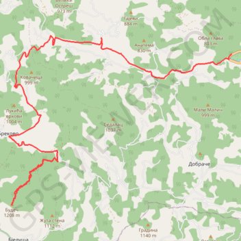
Trasa 016
- Distance: 12.7 mi
- Elevation gain: 670 m
- Maximum elevation: 1,193 m
- Elevation loss: 1,058 m
- Minimum elevation: 391 m
- Moving time: 3 h 16 m
- Moving speed: 3.9 mph
- Maximum speed: 33.2 mph
- Total time: 5 h 7 m
- Global speed: 2.5 mph
Interactive trail map
Trail profile
- Distance: 12.7 mi
- Elevation gain: 670 m
- Maximum elevation: 1,193 m
- Elevation loss: 1,058 m
- Minimum elevation: 391 m
- Moving time: 3 h 16 m
- Moving speed: 3.9 mph
- Maximum speed: 33.2 mph
- Total time: 5 h 7 m
- Global speed: 2.5 mph
About this trail
Name: Trasa 016 trail, distance, elevation, map, profile, GPS track
Coordinates: 43.62424 20.01364 43.66964 20.09663
Other hiking, mountain biking, running and outdoor activity trails
Click on a trail to view its statistics, map and profile.
2022_Yu
Slovenia > Ajdovščina > Žapuže
Distance: 1,526.9 mi • Elevation gain: 32,048 m • Maximum elevation: 1,950 m
Trenutna trasa: 10 SIJ 2021 10:40
Serbia > Central Serbia > Zlatibor Administrative District > Arilje Municipality > Dobrace
Distance: 10.7 mi • Elevation gain: 683 m • Maximum elevation: 1,082 m