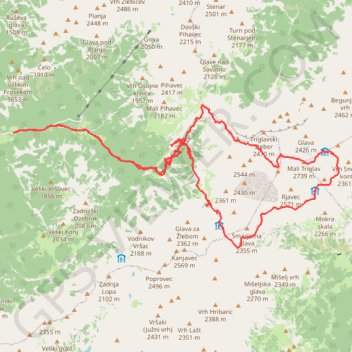
TRIGLAV por la ferrata Plemanice
- Distance: 18.4 mi
- Elevation gain: 3,390 m
- Maximum elevation: 2,833 m
- Elevation loss: 3,391 m
- Minimum elevation: 659 m
Interactive trail map
Trail profile
- Distance: 18.4 mi
- Elevation gain: 3,390 m
- Maximum elevation: 2,833 m
- Elevation loss: 3,391 m
- Minimum elevation: 659 m
About this trail
Name: TRIGLAV por la ferrata Plemanice trail, distance, elevation, map, profile, GPS track
Start: Trenta, Pri Cerkvi, Bovec, Slovenia (46.38248 13.76238)
End: Trenta, Pri Cerkvi, Bovec, Slovenia (46.38247 13.76229)
Coordinates: 46.36054 13.76229 46.38795 13.85267
Other hiking, mountain biking, running and outdoor activity trails
Click on a trail to view its statistics, map and profile.
Bled - Bohinj
File with points/tracks from Locus Map/4.11.1
Distance: 22.7 mi • Elevation gain: 740 m • Maximum elevation: 590 m
Триглав
Distance: 4.0 mi • Elevation gain: 1,952 m • Maximum elevation: 2,833 m
Alpy Julijskie - Aljazev Dom - M. Triglav, Triglav
Distance: 10.3 mi • Elevation gain: 2,458 m • Maximum elevation: 2,829 m