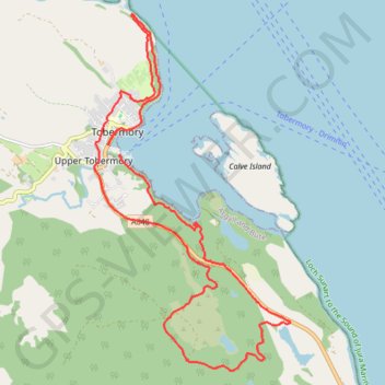
Tobermory
A variety of terrains and weather conditions
- Distance: 10.1 mi
- Elevation gain: 414 m
- Maximum elevation: 118 m
- Elevation loss: 416 m
- Minimum elevation: 0 m
- Moving time: 2 h 57 m
- Moving speed: 3.4 mph
- Maximum speed: 8.8 mph
- Total time: 3 h 6 m
- Global speed: 3.2 mph
Interactive trail map
Trail profile
- Distance: 10.1 mi
- Elevation gain: 414 m
- Maximum elevation: 118 m
- Elevation loss: 416 m
- Minimum elevation: 0 m
- Moving time: 2 h 57 m
- Moving speed: 3.4 mph
- Maximum speed: 8.8 mph
- Total time: 3 h 6 m
- Global speed: 3.2 mph
About this trail
Name: Tobermory trail, distance, elevation, map, profile, GPS track
Coordinates: 56.59392 -6.07306 56.63694 -6.03012
Topography: Argyll and Bute topographic map, elevation, terrain