Hillwalk Hundleshope Glenrath Dollar Law Black Cleugh
- Distance: 20.3 mi
- Elevation gain: 1,390 m
- Maximum elevation: 816 m
- Elevation loss: 1,391 m
- Minimum elevation: 233 m
- Moving time: 8 h 6 m
- Moving speed: 2.5 mph
- Maximum speed: 21.2 mph
- Total time: 8 h 45 m
- Global speed: 2.3 mph
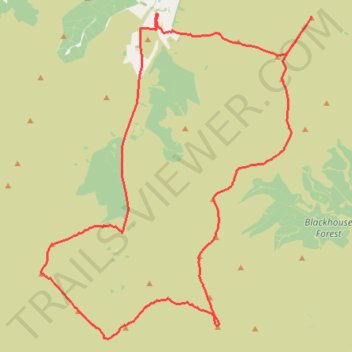
Interactive trail map
Trail profile
- Distance: 20.3 mi
- Elevation gain: 1,390 m
- Maximum elevation: 816 m
- Elevation loss: 1,391 m
- Minimum elevation: 233 m
- Moving time: 8 h 6 m
- Moving speed: 2.5 mph
- Maximum speed: 21.2 mph
- Total time: 8 h 45 m
- Global speed: 2.3 mph
About this trail
Name: Hillwalk Hundleshope Glenrath Dollar Law Black Cleugh trail, distance, elevation, map, profile, GPS track
Start: Scottish Borders, Scotland, EH45 9JW, United Kingdom (55.59029 -3.26539)
End: Scottish Borders, Scotland, EH45 9JW, United Kingdom (55.59021 -3.26543)
Coordinates: 55.51438 -3.30831 55.59399 -3.19149
Topography: Scottish Borders topographic map, elevation, terrain