Thank you for supporting this site ❤️
Make a donation
Make a donation
Gear up for your next adventure:
As an Amazon Associate, this site earns from qualifying purchases at no extra cost to you.
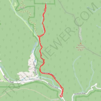
Trail off Old House Gap Road
- Distance: 3.0 mi
- Elevation gain: 223 m
- Maximum elevation: 808 m
- Elevation loss: 228 m
- Minimum elevation: 651 m
- Moving time: 54 m 33 s
- Moving speed: 3.2 mph
- Maximum speed: 7.5 mph
- Total time: 54 m 33 s
- Global speed: 3.2 mph
Interactive trail map
Thank you for supporting this site ❤️
Make a donation
Make a donation
Gear up for your next adventure:
As an Amazon Associate, this site earns from qualifying purchases at no extra cost to you.
Trail profile
- Distance: 3.0 mi
- Elevation gain: 223 m
- Maximum elevation: 808 m
- Elevation loss: 228 m
- Minimum elevation: 651 m
- Moving time: 54 m 33 s
- Moving speed: 3.2 mph
- Maximum speed: 7.5 mph
- Total time: 54 m 33 s
- Global speed: 3.2 mph
Thank you for supporting this site ❤️
Make a donation
Make a donation
Gear up for your next adventure:
As an Amazon Associate, this site earns from qualifying purchases at no extra cost to you.
About this trail
Name: Trail off Old House Gap Road trail, distance, elevation, map, profile, GPS track
Start: Roseboro Road, Roseborough, Avery County, North Carolina, 28616, United States (36.03201 -81.80373)
End: Roseboro Road, Roseborough, Avery County, North Carolina, 28616, United States (36.03167 -81.80342)
Coordinates: 36.03167 -81.80860 36.04817 -81.80301
Thank you for supporting this site ❤️
Make a donation
Make a donation
Gear up for your next adventure:
As an Amazon Associate, this site earns from qualifying purchases at no extra cost to you.