Thank you for supporting this site ❤️
Make a donation
Make a donation
Gear up for your next adventure:
As an Amazon Associate, this site earns from qualifying purchases at no extra cost to you.
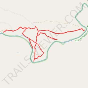
Makuya Nature Reserve
- Distance: 16.1 mi
- Elevation gain: 398 m
- Maximum elevation: 362 m
- Elevation loss: 398 m
- Minimum elevation: 278 m
- Moving time: 3 h 16 m
- Moving speed: 4.9 mph
- Maximum speed: 13.3 mph
- Total time: 5 h 4 m
- Global speed: 3.2 mph
Interactive trail map
Thank you for supporting this site ❤️
Make a donation
Make a donation
Gear up for your next adventure:
As an Amazon Associate, this site earns from qualifying purchases at no extra cost to you.
Trail profile
- Distance: 16.1 mi
- Elevation gain: 398 m
- Maximum elevation: 362 m
- Elevation loss: 398 m
- Minimum elevation: 278 m
- Moving time: 3 h 16 m
- Moving speed: 4.9 mph
- Maximum speed: 13.3 mph
- Total time: 5 h 4 m
- Global speed: 3.2 mph
Thank you for supporting this site ❤️
Make a donation
Make a donation
Gear up for your next adventure:
As an Amazon Associate, this site earns from qualifying purchases at no extra cost to you.
About this trail
Name: Makuya Nature Reserve trail, distance, elevation, map, profile, GPS track
Coordinates: -22.52222 30.99472 -22.49767 31.05703
Thank you for supporting this site ❤️
Make a donation
Make a donation
Gear up for your next adventure:
As an Amazon Associate, this site earns from qualifying purchases at no extra cost to you.