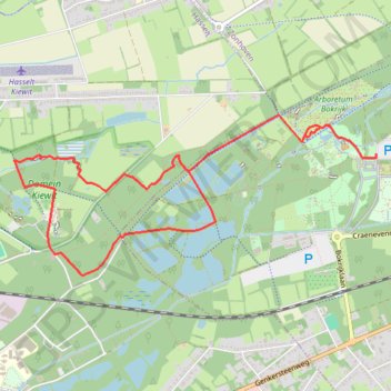
Bokrijk-8.3
name=bokrijk-8.3
- Distance: 5.1 mi
- Elevation gain: 23 m
- Maximum elevation: 48 m
- Elevation loss: 23 m
- Minimum elevation: 35 m
Interactive trail map
Trail profile
- Distance: 5.1 mi
- Elevation gain: 23 m
- Maximum elevation: 48 m
- Elevation loss: 23 m
- Minimum elevation: 35 m
About this trail
Name: Bokrijk-8.3 trail, distance, elevation, map, profile, GPS track
Start: Genk, Hasselt, Limburg, Flanders, 3600, Belgium (50.96457 5.41137)
End: P1 Kasteel, Craenevenne, Genk, Hasselt, Limburg, Flanders, 3600, Belgium (50.96483 5.41174)
Coordinates: 50.95672 5.37347 50.96741 5.41174
Other hiking, mountain biking, running and outdoor activity trails
Click on a trail to view its statistics, map and profile.
Riethoven naar Oostenrijk
Netherlands > North Brabant > Riethoven > Eind
Distance: 573.0 mi • Elevation gain: 13,629 m • Maximum elevation: 1,897 m
Eurovelo 15 - Strasbourg Rotterdam
France > Grand Est > Bas-Rhin > Strasbourg
Distance: 554.1 mi • Elevation gain: 2,104 m • Maximum elevation: 146 m