Make a donation
Gear up for your next adventure:
As an Amazon Associate, this site earns from qualifying purchases at no extra cost to you.
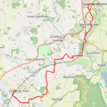
Walk to Saxmundham
- Distance: 11.1 mi
- Elevation gain: 96 m
- Maximum elevation: 30 m
- Elevation loss: 108 m
- Minimum elevation: 2 m
- Moving time: 3 h 26 m
- Moving speed: 3.2 mph
- Maximum speed: 4.9 mph
- Total time: 3 h 35 m
- Global speed: 3.1 mph
Interactive trail map
Make a donation
Gear up for your next adventure:
As an Amazon Associate, this site earns from qualifying purchases at no extra cost to you.
Trail profile
- Distance: 11.1 mi
- Elevation gain: 96 m
- Maximum elevation: 30 m
- Elevation loss: 108 m
- Minimum elevation: 2 m
- Moving time: 3 h 26 m
- Moving speed: 3.2 mph
- Maximum speed: 4.9 mph
- Total time: 3 h 35 m
- Global speed: 3.1 mph
Make a donation
Gear up for your next adventure:
As an Amazon Associate, this site earns from qualifying purchases at no extra cost to you.
About this trail
Name: Walk to Saxmundham trail, distance, elevation, map, profile, GPS track
Start: B1078, Campsea Ashe, East Suffolk, Suffolk, England, IP13 0QP, United Kingdom (52.15117 1.39825)
Coordinates: 52.14177 1.39378 52.21414 1.49198
Topography: East Suffolk topographic map, elevation, terrain
Make a donation
Gear up for your next adventure:
As an Amazon Associate, this site earns from qualifying purchases at no extra cost to you.
Other hiking, mountain biking, running and outdoor activity trails
Click on a trail to view its statistics, map and profile.
Tunstall Forest and Rendlesham Forest Loop from Bawdsey Manor
United Kingdom > England > Suffolk > East Suffolk > Bawdsey
Distance: 40.5 mi • Elevation gain: 403 m • Maximum elevation: 34 m