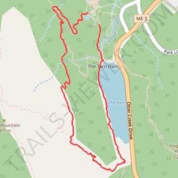
Loop Walk via The Tarn Dam, Ladder Trail and Schiffer Path
- Distance: 2.3 mi
- Elevation gain: 254 m
- Maximum elevation: 256 m
- Elevation loss: 253 m
- Minimum elevation: 27 m
- Moving time: 1 h 23 m
- Moving speed: 1.6 mph
- Maximum speed: 5.3 mph
- Total time: 2 h 6 m
- Global speed: 1.1 mph
Interactive trail map
Trail profile
- Distance: 2.3 mi
- Elevation gain: 254 m
- Maximum elevation: 256 m
- Elevation loss: 253 m
- Minimum elevation: 27 m
- Moving time: 1 h 23 m
- Moving speed: 1.6 mph
- Maximum speed: 5.3 mph
- Total time: 2 h 6 m
- Global speed: 1.1 mph
About this trail
Name: Loop Walk via The Tarn Dam, Ladder Trail and Schiffer Path trail, distance, elevation, map, profile, GPS track
Start: Jesup Path, Bar Harbor, Hancock County, Maine, United States (44.36087 -68.20744)
End: Emery Path, Bar Harbor, Hancock County, Maine, United States (44.36165 -68.20840)
Coordinates: 44.35121 -68.21166 44.36207 -68.20502
Other hiking, mountain biking, running and outdoor activity trails
Click on a trail to view its statistics, map and profile.
Cadillac Mountain Loop Trail
United States > Maine > Hancock County > Bar Harbor
Distance: 7.5 mi • Elevation gain: 564 m • Maximum elevation: 459 m