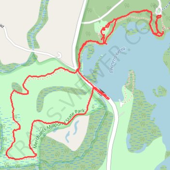
Lassiter Trail and Bennetts Creek Loop Trail
- Distance: 3.9 mi
- Elevation gain: 24 m
- Maximum elevation: 14 m
- Elevation loss: 23 m
- Minimum elevation: 2 m
- Moving time: 1 h 25 m
- Moving speed: 2.8 mph
- Maximum speed: 8.5 mph
- Total time: 1 h 45 m
- Global speed: 2.2 mph
Interactive trail map
Trail profile
- Distance: 3.9 mi
- Elevation gain: 24 m
- Maximum elevation: 14 m
- Elevation loss: 23 m
- Minimum elevation: 2 m
- Moving time: 1 h 25 m
- Moving speed: 2.8 mph
- Maximum speed: 8.5 mph
- Total time: 1 h 45 m
- Global speed: 2.2 mph
About this trail
Name: Lassiter Trail and Bennetts Creek Loop Trail trail, distance, elevation, map, profile, GPS track
Start: Visitor Center, Lassiter Trail, Gates County, North Carolina, United States (36.43689 -76.69911)
End: Lassiter Trail, Gates County, North Carolina, United States (36.43711 -76.69882)
Coordinates: 36.42728 -76.70803 36.43803 -76.69396
Other hiking, mountain biking, running and outdoor activity trails
Click on a trail to view its statistics, map and profile.
Lassiter Trail in Merchants Millpond State Park
United States > North Carolina > Gates County
Distance: 6.2 mi • Elevation gain: 39 m • Maximum elevation: 19 m
Coleman Trail loop
United States > North Carolina > Gates County
Distance: 2.3 mi • Elevation gain: 17 m • Maximum elevation: 14 m