Thank you for supporting this site ❤️
Make a donation
Make a donation
Gear up for your next adventure:
As an Amazon Associate, this site earns from qualifying purchases at no extra cost to you.
Tracked with OSMTracker for Android™
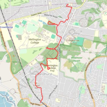
Local Cycle
- Distance: 3.5 mi
- Elevation gain: 79 m
- Maximum elevation: 99 m
- Elevation loss: 48 m
- Minimum elevation: 65 m
Interactive trail map
Thank you for supporting this site ❤️
Make a donation
Make a donation
Gear up for your next adventure:
As an Amazon Associate, this site earns from qualifying purchases at no extra cost to you.
Trail profile
- Distance: 3.5 mi
- Elevation gain: 79 m
- Maximum elevation: 99 m
- Elevation loss: 48 m
- Minimum elevation: 65 m
Thank you for supporting this site ❤️
Make a donation
Make a donation
Gear up for your next adventure:
As an Amazon Associate, this site earns from qualifying purchases at no extra cost to you.
About this trail
Name: Tracked with OSMTracker for Android™ trail, distance, elevation, map, profile, GPS track
End: Nugee Court, Crowthorne, Bracknell Forest, England, RG45 6SJ, United Kingdom (51.37112 -0.79525)
Coordinates: 51.34716 -0.80792 51.37142 -0.79354
Topography: Bracknell Forest topographic map, elevation, terrain
Thank you for supporting this site ❤️
Make a donation
Make a donation
Gear up for your next adventure:
As an Amazon Associate, this site earns from qualifying purchases at no extra cost to you.