Thank you for supporting this site ❤️
Make a donation
Make a donation
Gear up for your next adventure:
As an Amazon Associate, this site earns from qualifying purchases at no extra cost to you.
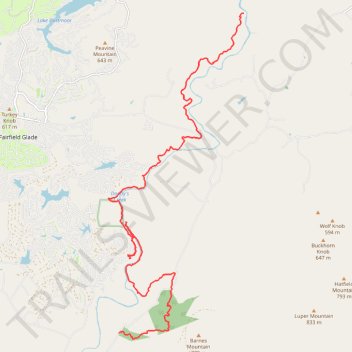
Cumberland Trail (CT) Daddy's Creek to North Peavine Campsite via Daddy's Creek Trail and Devil's Breakfast Table
- Distance: 15.1 mi
- Elevation gain: 569 m
- Maximum elevation: 590 m
- Elevation loss: 678 m
- Minimum elevation: 412 m
- Moving time: 5 h 31 m
- Moving speed: 2.7 mph
- Maximum speed: 5.4 mph
- Total time: 6 h 10 m
- Global speed: 2.4 mph
Interactive trail map
Thank you for supporting this site ❤️
Make a donation
Make a donation
Gear up for your next adventure:
As an Amazon Associate, this site earns from qualifying purchases at no extra cost to you.
Trail profile
- Distance: 15.1 mi
- Elevation gain: 569 m
- Maximum elevation: 590 m
- Elevation loss: 678 m
- Minimum elevation: 412 m
- Moving time: 5 h 31 m
- Moving speed: 2.7 mph
- Maximum speed: 5.4 mph
- Total time: 6 h 10 m
- Global speed: 2.4 mph
Thank you for supporting this site ❤️
Make a donation
Make a donation
Gear up for your next adventure:
As an Amazon Associate, this site earns from qualifying purchases at no extra cost to you.
About this trail
Name: Cumberland Trail (CT) Daddy's Creek to North Peavine Campsite via Daddy's Creek Trail and Devil's Breakfast Table trail, distance, elevation, map, profile, GPS track
Coordinates: 35.94679 -84.85619 36.03432 -84.81128
Thank you for supporting this site ❤️
Make a donation
Make a donation
Gear up for your next adventure:
As an Amazon Associate, this site earns from qualifying purchases at no extra cost to you.