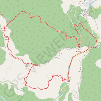
Vlaška planina
- Distance: 11.5 mi
- Elevation gain: 1,257 m
- Maximum elevation: 1,442 m
- Elevation loss: 1,258 m
- Minimum elevation: 494 m
- Moving time: 5 h 56 m
- Moving speed: 1.9 mph
- Maximum speed: 7.0 mph
- Total time: 9 h 54 m
- Global speed: 1.2 mph
Interactive trail map
Trail profile
- Distance: 11.5 mi
- Elevation gain: 1,257 m
- Maximum elevation: 1,442 m
- Elevation loss: 1,258 m
- Minimum elevation: 494 m
- Moving time: 5 h 56 m
- Moving speed: 1.9 mph
- Maximum speed: 7.0 mph
- Total time: 9 h 54 m
- Global speed: 1.2 mph
About this trail
Name: Vlaška planina trail, distance, elevation, map, profile, GPS track
Coordinates: 42.96213 22.58747 42.99327 22.63785
Other hiking, mountain biking, running and outdoor activity trails
Click on a trail to view its statistics, map and profile.
Trasa 013
Serbia > Central Serbia > Pirot Administrative District > Dimitrovgrad Municipality > Poganovo
Distance: 11.4 mi • Elevation gain: 1,099 m • Maximum elevation: 1,446 m
Vlaška planina: DREN (1.324 m) - PANICA (1.442m) - VRTIBOG (...
Serbia > Central Serbia > Pirot Administrative District > Dimitrovgrad Municipality > Trnski Odorovci
Distance: 8.7 mi • Elevation gain: 1,061 m • Maximum elevation: 1,445 m