Thank you for supporting this site ❤️
Make a donation
Make a donation
Gear up for your next adventure:
As an Amazon Associate, this site earns from qualifying purchases at no extra cost to you.
Grassi Lakes Loop
Interactive trail map
Thank you for supporting this site ❤️
Make a donation
Make a donation
Gear up for your next adventure:
As an Amazon Associate, this site earns from qualifying purchases at no extra cost to you.
Trail profile
- Distance: 2.7 mi
- Elevation gain: 302 m
- Maximum elevation: 1,691 m
- Elevation loss: 302 m
- Minimum elevation: 1,421 m
Thank you for supporting this site ❤️
Make a donation
Make a donation
Gear up for your next adventure:
As an Amazon Associate, this site earns from qualifying purchases at no extra cost to you.
About this trail
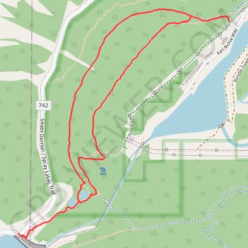
Name: Grassi Lakes Loop trail, distance, elevation, map, profile, GPS track
Coordinates: 51.07067 -115.41078 51.08164 -115.39472
Thank you for supporting this site ❤️
Make a donation
Make a donation
Gear up for your next adventure:
As an Amazon Associate, this site earns from qualifying purchases at no extra cost to you.