Thank you for supporting this site ❤️
Make a donation
Make a donation
Gear up for your next adventure:
As an Amazon Associate, this site earns from qualifying purchases at no extra cost to you.
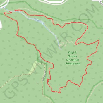
Honeybee Trail - Watoga State Park
- Distance: 4.3 mi
- Elevation gain: 272 m
- Maximum elevation: 912 m
- Elevation loss: 274 m
- Minimum elevation: 742 m
- Moving time: 13 m 5 s
- Moving speed: 19.9 mph
- Maximum speed: 27.9 mph
- Total time: 13 m 5 s
- Global speed: 19.9 mph
Interactive trail map
Thank you for supporting this site ❤️
Make a donation
Make a donation
Gear up for your next adventure:
As an Amazon Associate, this site earns from qualifying purchases at no extra cost to you.
Trail profile
- Distance: 4.3 mi
- Elevation gain: 272 m
- Maximum elevation: 912 m
- Elevation loss: 274 m
- Minimum elevation: 742 m
- Moving time: 13 m 5 s
- Moving speed: 19.9 mph
- Maximum speed: 27.9 mph
- Total time: 13 m 5 s
- Global speed: 19.9 mph
Thank you for supporting this site ❤️
Make a donation
Make a donation
Gear up for your next adventure:
As an Amazon Associate, this site earns from qualifying purchases at no extra cost to you.
About this trail
Name: Honeybee Trail - Watoga State Park trail, distance, elevation, map, profile, GPS track
Start: Honey Bee Trail, Pocahontas County, West Virginia, United States (38.11938 -80.15425)
End: Honey Bee Trail, Pocahontas County, West Virginia, United States (38.11922 -80.15549)
Coordinates: 38.10542 -80.15675 38.11945 -80.13631
Thank you for supporting this site ❤️
Make a donation
Make a donation
Gear up for your next adventure:
As an Amazon Associate, this site earns from qualifying purchases at no extra cost to you.